How to plan a walking route on Google Maps
- Open Directions in Google Maps and choose the walking icon.
- Set your start and finish. For a city day, use a station, hotel, or first landmark as the starting point.
- Add each stop. Use “Add destination” for the museums, markets, parks, and viewpoints you want to include.
- Drag the stops into order. Google Maps will route the order you give it, but it will not automatically build the most sensible sightseeing sequence.
- Check the total walking time. Leave room for time inside attractions, meals, and the extra wandering a route line cannot predict.
- Share the route. Send it to your phone or travel companions, then use live walking directions once you are on the street.
This works well for a short list of places you already know. If you still need to choose the stops, group them by neighborhood, or split them across several days, build the itinerary first and use Google Maps for turn-by-turn navigation afterward.
What Google Maps is good at
Credit where it is due. For a single walk from where you are standing to one destination, nothing beats it. Live directions, accurate walk times, transit options when your feet give out, and Street View to scout a corner before you get there. If your question is "how do I get to the museum from here," Google Maps answers it perfectly.
The trouble starts when the question becomes "what should a good day of walking in this neighborhood actually look like." That is a different problem, and Maps was never built to solve it.
Where it stops being useful
Drop ten places you want to see into Google Maps and you will hit the limits fast:
- It won't order your stops. You can add waypoints, but you have to arrange them yourself. Get the order wrong and the route zigzags across town.
- It has no concept of a day. There is no sense of pace, lunch, or how much walking is reasonable before you are done. A route is just a line, not a plan.
- Saved lists are static. Starring places builds a scatter of pins with no structure. You still have to eyeball which ones cluster together.
- It ignores neighborhoods. Maps treats the city as coordinates, not as areas with their own character. The whole point of a good walking day is staying in one area long enough to feel it.
What to look for in an alternative
Before the list, here is what actually matters when you pick a tool for planning a day on foot:
- It thinks in days, not points. A real planner gives you a route with a beginning, a middle, and a sensible end.
- It groups by area. Stops near each other land on the same day, so you spend the day walking rather than commuting.
- It provides an offline reference. Save a list of stops or a PDF before leaving Wi-Fi, and check separately whether navigation works offline.
- It is honest about cost. Free with no account beats a free trial that wants your card.
The best self-guided walking tour planners
Here is how the main self-guided walking tour planners compare for building an actual day on foot, versus Google Maps:
| Tool | Plans a full day | Groups by area | Offline | Free | Best for |
|---|---|---|---|---|---|
| CityWalk Plan | Yes, day by day | Yes | Print or save a PDF for reading; map needs internet | Yes, no sign-up | A ready walking day you can edit |
| Google Maps | No, point to point | No | Downloaded areas; no offline walking directions | Yes | Live turn-by-turn and transit |
| Wanderlog | Partly (trip lists) | No | Paid tier | Freemium | Organizing a whole trip |
| Komoot | Yes (routes) | No, trail-based | Yes | Freemium | Trails and long walks |
| Visit A City | Yes (templates) | No | Paid tier | Freemium | Pre-made hour-by-hour plans |
| GPSmyCity | Yes (guided walks) | Somewhat | Yes | Freemium | GPS-guided article walks |
The honest rundown of each:
CityWalk Plan
A free walking-itinerary generator. You pick a city and trip length, and it builds a day-by-day route grouped by neighborhood, which you can edit, reorder, share, or export. Print or save a PDF for offline reading; the interactive map needs internet access. No sign-up. It covers 50+ cities from a curated catalog of real places, so it fits people who want a ready day plan they can tweak rather than build from scratch. The honest limit: it works from a set catalog, so a tiny town off the list is not covered.
Wanderlog
A strong trip organizer. It is good at the whole trip, including lists, reservations, road-trip stops, and planning with other people. It is less focused on sequencing a single walking day by neighborhood, so it shines more as a trip database than a day route. Free tier with paid upgrades.
Komoot
Built for hiking, cycling, and walking with turn-by-turn directions and real terrain and elevation data. If your idea of a walk is a long riverside route or a trail rather than a sightseeing crawl through a city center, this is the better fit. Some regions are free, others are paid.
Visit A City
Offers pre-made city itineraries broken into hours and days. Useful if you want a template to follow and adjust, though the routes are fixed plans rather than something you generate around your own pace.
GPSmyCity
Offers GPS-guided walks built around travel articles, with offline maps you pay to unlock per city. Good if you want a narrated, article-style walk to follow. It leans on fixed published walks rather than generating a route around your own days and pace, so it is less flexible for planning a custom day.
AllTrails
Worth knowing about, but it is for marked trails and nature walks, not city sightseeing. If you want a coastal path or a park loop, it is excellent. For a walk through old-town streets, it is the wrong tool.
Google Maps lists, done by hand
If you would rather not add another app, you can make Maps work: save your places to a list, then look for clusters of pins and walk one cluster per day. It is doable. It is also tedious, and you are still doing by eye the grouping a planner does for you.
When Google Maps is still the right call
None of this means dropping Maps. Keep it for what it does best: live navigation once you are walking, checking transit when you want to skip a long stretch, and looking up a single address. The smart setup is to plan the shape of the day in a walking planner, then hand the turn-by-turn to Google Maps once you are out the door.
Use a two-layer planning workflow
The cleanest workflow separates itinerary decisions from live navigation. In the planning layer, choose the neighborhood, order the places, decide which stops are optional, and keep the day within your energy budget. Export or save that ordered list. In the navigation layer, open the next destination in a current map service and let it respond to closures, construction, and your actual position.
Before leaving Wi-Fi, verify that every important place has a full address and that similarly named branches have not been confused. Save the hotel, final transit station, and one backup indoor stop. Google Maps does not provide walking directions while offline, even when you have downloaded the area. Print or save your itinerary as a PDF for offline reading; that copy is a list of stops, not live navigation. CityWalk Plan’s interactive map needs internet access.
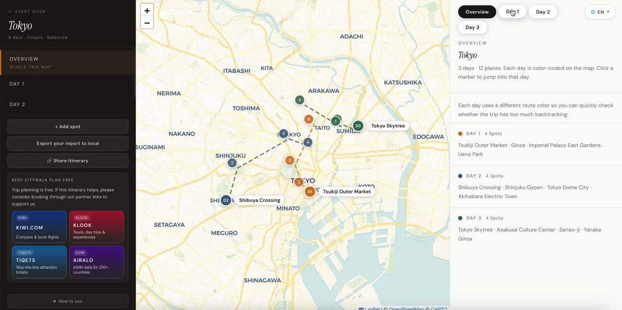
CityWalk Plan’s map organizes sightseeing stops and previews straight connections between verified coordinates. Those lines do not measure street distance, walking time, or accessibility. Select one day, then use Google Maps or Apple Maps in the day panel or the export dialog’s Open in maps section. Each map service recalculates current street directions; it does not reproduce the straight preview lines.
For Google Maps, CityWalk Plan opens up to five ordered stops in one walking link. Longer days have numbered, continuous parts that share the last stop of one part with the first stop of the next, so you can follow every leg in order. This is the planner’s mobile-safe handoff, not a universal Google Maps stop limit; Google’s supported URL waypoints vary by platform. For Apple Maps, a day with one or two stops opens directly; a longer day offers numbered point-to-point walking legs. Choose the day explicitly and open its parts or legs in sequence.
A five-minute handoff check
- Confirm the ordered stops and mark which two can be dropped.
- Check today's opening hours on the venue's official page.
- Open the first real street route and inspect any unusually long connection.
- Save the return address, transit fallback details, and essential contacts for offline reading.
- Recheck live conditions during the day instead of treating yesterday's plan as navigation.
This division of labor is more dependable than expecting one app to be a destination catalog, trip editor, live map, accessibility database, and transit control room at once. Plan with the tool that makes the day coherent; navigate with the tool that has the freshest local conditions.
Frequently asked questions
Can Google Maps plan a multi-stop walking day?
It can route several stops in an order you set, but it will not choose the order for you or group the stops by neighborhood. For a day with eight or ten places, you end up dragging pins around to stop the route doubling back.
Is there a free alternative to Google Maps for walking tours?
Yes. CityWalk Plan is free and builds a day-by-day walking route grouped by neighborhood, with no sign-up. Wanderlog and Komoot also have free tiers, though they are built more for trip organizing and trail routing respectively.
What is the best app for self-guided walking tours?
It depends on the day. For a sequenced sightseeing day in a city, a walking-itinerary planner works best. For a marked trail with narration, a dedicated audio-tour app is better. For a nature or long-distance walk, Komoot or AllTrails handle terrain and elevation.
Does Google Maps work offline for walking?
No. Downloaded Google Maps areas do not provide walking directions while you are offline. Save essential addresses and print or save your itinerary as a PDF for offline reading. CityWalk Plan's interactive map still needs internet access.